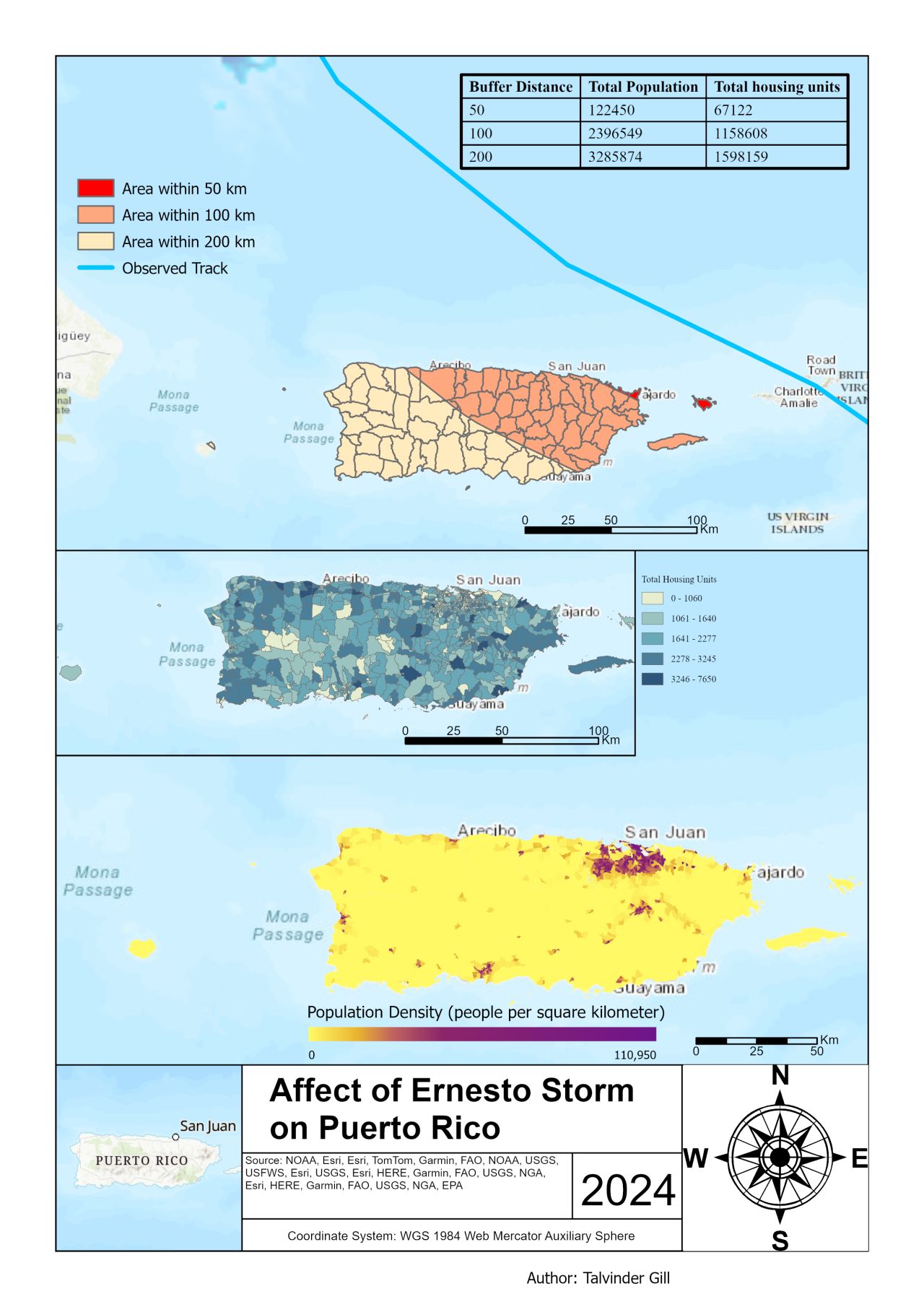
Talvinder Gill

GIS Specialist & Spatial Data Analyst

Turning geospatial data into impactful solutions

View My Projects

About Me

Talvinder Gill

I am a dedicated GIS student at BCIT, skilled in mapping, spatial analysis, and data visualization with tools like ArcGIS Pro, QGIS, and FME. My passion lies in using geospatial technologies to tackle real-world challenges and deliver meaningful insights.

Currently pursuing a Bachelor of Technology in Geographic Information Systems, I combine technical proficiency with a commitment to creating actionable visualizations for urban planning, disaster management, and environmental protection.

Education

BCIT Logo

Bachelor of Technology in Geographic Information Systems (GIS)

British Columbia Institute of Technology

January 2024 – April 2026

UFV Logo

Diploma in Geography

University of the Fraser Valley

January 2019 – December 2020

Technical Skills

GIS & Mapping

ArcGIS Pro ArcGIS Online QGIS PCI Geomatica FieldMaps Survey123

Programming & Data

Python SQL PostgreSQL/PostGIS FME

Cloud & Tools

AWS AutoCAD Blender MS Office Suite

GIS Projects

East City Museum Property Evaluation

East City Museum Property Evaluation

Assessed property values and land use zoning around the East City Museum using ArcGIS Pro.

Navarro River Watershed Drainage Analysis

Navarro River Watershed Drainage Analysis

Created a map highlighting soil drainage levels to support land use planning.

Metro Vancouver Flood Risk Mapping

Metro Vancouver Flood Risk Mapping

Developed flood risk maps for Metro Vancouver, integrating flood zones and infrastructure data.

Kelowna Fire Hydrant Vulnerability

Kelowna Fire Hydrant Vulnerability

Mapped building parcels and fire hydrants in Kelowna to identify vulnerable structures.

Ernesto Storm Impact Analysis

Ernesto Storm Impact Analysis

Visualized Hurricane Ernesto's impact on Puerto Rico with multi-buffer zones.

Certifications